Unsettled Weather in the West; While the Midwest/Northeast Thaws out for the Time being…..
Hope everyone is having a good week. I have been trying to post this week, but work has gotten in the away. A week ago I discussed the big pattern change for this past week, and was hoping for Winter to finally arrive in CA, and ease off in the Northeast. Well, one can hope! Earlier this past week, the Northeast got pounded again with more snow and another PV. After experiencing the Bombcyclone first hand 2 weeks ago, and 9 days of PV, the Northeast/Midwest has been battered this winter. After the PV pulled out a few days ago and the Jet stream became Zonal, all the teleconnection signs were there for the West Coast/CA to get their first taste of winter. Most people in the news and on social media feel that the 48 hours of storms to hit CA/SoCal and basically decimate Montecito 10+ days ago, were a sign of winter is here. I would argue that is not the case. Those two storms over a 48 hour period were atypical of the weather pattern for this season in North American and the US (CONUS). With persistent high pressure on the West, and a meridional flow pattern in North America this winter, I would say those storms were rogue and cut off from the main jet stream. I get asked what the weather is going to be like the rest of the winter……so let’s get into the remainder of the month and what February/March look like from my point of view.
Inter-seasonal Summary:
As everyone has experienced this winter so far in the CONUS, snow/rain has been scarce in CA this winter/fall, as high pressure has dominated the region with hot temps, dry weather and fires. On the flip side, the Midwest/Northeast as been inundated with the Polar Vortex and Snow/Ice since the middle of December. I have discussed this on previous posts, regarding how the PV had effected the Midwest/Northeast and how much snow they should get (See the 11/30/17 discussion). However, this pattern has changed to more of a zonal flow this past week, as the past few days CA has experienced an “inside slider” which is a trough of low pressure entering CA mainly over land, rather than having over the water trajectory. This pattern is what CA saw in the middle of December, in which moisture starved storms swing down the state with mountain snow, and very little rain in the valleys and coast. By the time they get down to SoCal, it is just cold with mist. Even in NorCal, most of the storms are splitting, where some of the energy goes to the north, and the other energy goes to Baja CA. When the storms split, most of the energy goes into Utah and Colorado (They are going to get hit tonight/tomorrow with a big storm), and the rest goes south of SoCal. Example – The Sierra Nevada was forecasted to get a decent storm of 2′-4′ the past two days…… only for that region to get half of that, as the storm split and went into Utah and is headed to Colorado tonight. SoCal got just windy/cold temps, with light dusting of snow in the mountain. After looking at the SST, look at the warm water off of the coast of CA
(Click to Enlarge)

As you can see, LA Nina is in full effect, but there are anomalous warm water off the coast of CA. I believe the high pressure ridge axis is set up to close to the coast, and splitting the system due to the warm water off of the coast of CA. Depending on where the ridge axis sets up, determines if Rain/Snow will come in off of the Pacific Ocean, and/or goes more inland, creating an inside slider. Currently, the ridge axis is set up at 40 to 45 degrees North, right off of the coast of CA/OR. This ridge needs to move/retrograde past 160 degrees west, in order for CA and SoCal to get some decent rain/snow in the area. Will that happen anytime soon? That is the million dollar questions!!!
As for the Midwest/Northeast, temps have moderated to above normal for the first time this winter, as snow has turned to rain and high temps of 40s to 50s will be the norm for the upcoming week. As the jet stream becomes zonal for the pacific, I don’t see the PV setting up anytime soon as there will be no east coast blocking setting up, which is good news for those of you in the Midwest/Northeast that were complaining to me about how bad the weather has been the past 6 weeks.
Long Range Forecast –
Currently, the models are completely all over the map. Any forecast over 5 to 6 days out, is subject to change. However, here is what we do know:
– The PNA index is currently negative, forecasted to go to neutral by Feb 1st, and be slightly positively the first week of February. This is subject to change, but any model forecast more than 7+ days out, is subject to change.
– The AO index (AKA the PV forecast index) is currently dropping to slightly negative , then moderate to neutral, then some ensemble models have it dropping very negative and some have it going positive after the 1st of Feb. If the AO goes very negative, the PV will emerge back in the midwest/northeast the 1st or 2nd week of February, and high pressure will emerge on the West Coast, if the PNA goes positive with with the AO going negative. This pattern change is TBD, as the models are trying to get a handle on what the teleconnection patterns are going to do week 2 and week 3. The CPC shows the following forecast for the next two weeks:
(Click to enlarge)
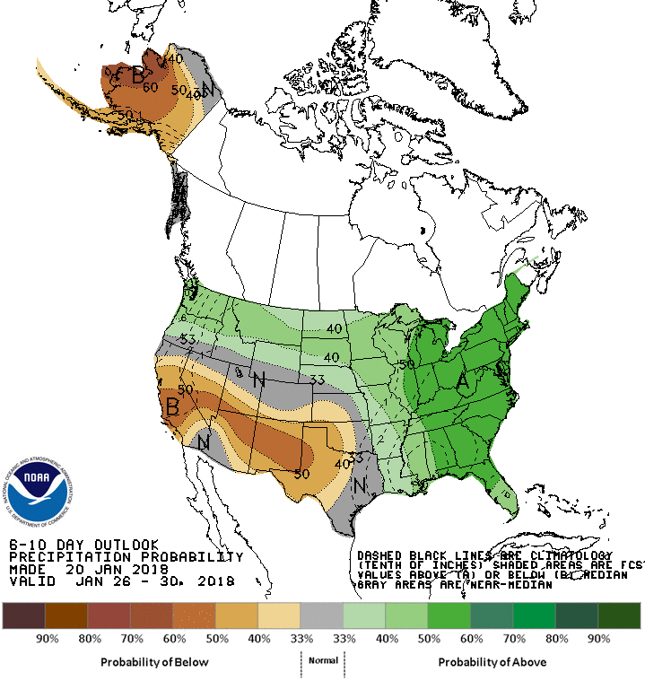

The pattern is pretty self explanatory. Above average temps in the Midwest/Northeast, but a lot of rain and maybe ice. The temps will run 10-20 degrees above normal for that region but above average precipitation. Again, this pattern is zonal, with the ridge axis near the coast of CA at 40 degrees west…..hence the dry forecast week 2.
For CA this week, another inside slider pattern will emerge, with below temps, and showery rain/modest snow in the mountains. SoCal again will be below temps this upcoming week, but only will get the tail end of the storms in NorCal. For the week 2 period, the GFS has this pattern setting up, but I am not sold on anything beyond the 7 day period currently. For CA to really get good storms, the Ridge Axis needs to retrograde east, and the jet stream needs to dig very south to get the moisture coming off of the pacific.
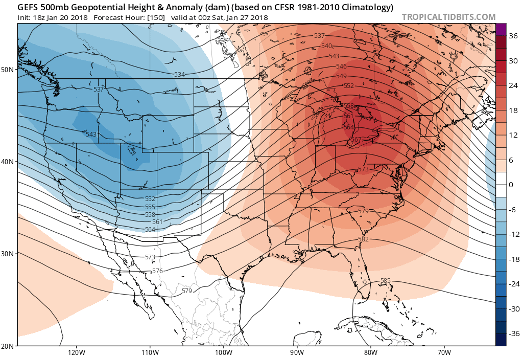
This is the GFS forecast for next weekend. After the 7 day period, everything is up for grabs!
About myself and the Real Weather Forecast:
For those of you who are just joining me on the blog, welcome. Although I end my discussions with Dr. J, I don’t have a PHD. I have taken courses in Meteorology, Climatology, and Oceanography. I have been involved with the AMS Association & the NWS LAX/Oxnard spotter program since the early 90’s. I merely use that tag line, as some people refer compare me in a tongue and cheek way with Dr.George Fischbeck, the old KABC meteorologist in the 70’s and 80’s. I have met him several times and it was a thrill of mine to pick his brain on forecasting and discussing the weather. For those of you who don’t know me, I have been studying forecast models, SST trends and teleconnection patterns since the early 90’s before the WWW was even born! At the end of the day, I want to give all my followers an idea of what the weather will be like and what the long range forecasts look like….. which is why I enjoy it so much, as it is a puzzle to me. I look at certain patterns and try to give my followers a snap shot of what is to come and when it will come, and what to expect. Currently, I have over 100 subscribers on my blog and counting. I have recently started a twitter feed, and I am gaining members daily. Please feel free to share this site and my twitter feed with anyone, and have them sign up for email alerts if they are interested. My twitter handle is @realexforecast
I look forward to the comments and suggestions for the site, and will be happy to answer any questions. I hope you enjoy the discussions as much as I like getting your thoughts!
Enjoy! Next discussion on Monday as we see what the long range models show!!
Dr. J
