While the Northeast digs out from the Bombgensis/Nor’Easter, California Braces for their first Rain Fall in over 200+ Days!! Major Mudslides in Burn Areas will Occur!
Quick Update tonight:
-The Northeast is currently digging out from the Bombgensis/Nor’Easter, as well as trying to thaw out from the PV that has gripped the Midwest/Northeast for the past 2+ weeks. After experiencing the PV and the Bombgensis/Nor’Easter firsthand, it has allowed me to appreciate how hardy the people are in that region. More on that on a future discussion this week, but I have some interesting thoughts on that once in a 20-30 year weather phenomenon! For now, temps will moderate a bit later this week, as 40’s are in the cards, with 50’s the following week. Hang in there for those of you who are visiting and/or live there.
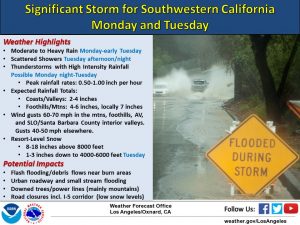
Attention turns to the big storm coming into CA tomorrow. A few days ago, it looked to be a Northern California storm….but models have trended it to central and Southern California. Below are some graphics from the NWS, that summarize the storm.
(Click to Enlarge)
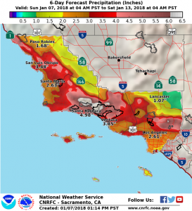
As you can see, this storm (which is really a one/two punch Monday and Tuesday), will provide serious hydrological issues for areas south of point conception, as well as providing serious mudslide conditions in the burn areas. Please, if you are in these areas, monitor the NWS service, and local agencies. Below are the rain totals that the models are predicting will fall through Tuesday night:
(Click to Enlarge)
As you can see, the bulls-eye is in Santa Barbara/Ventura. Even LA will get 2+”, which will make the Sylmar & Bel Air burn areas at risk for mud slides. Please be careful!!!
More later tomorrow night. After the storms exit SoCal Wednesday, high pressure kicks in for 80 degree weather for about 7 days or so, then big changes are forecasted for both the coasts. More on that later this week.
Update tomorrow on SoCal Storm!
Dr. J


