Fires Still Out of Control Out West; Northeast Gets First Snow Storm!!!
After a very challenging week in Southern California, the outlook remains grim for firefighters, based on the forecast models for the next two weeks out west. Looking at the models this morning, it is clear that things will be worse out west, before they get better. As I write this discussion, the West is still baking in hot, dry, very windy conditions, with about 10+ wildfires out of control, south of Pt. Conception. On the flip side, the Northeast is experiencing their first snow fall, with roughly 4″ to 8″ of snow through tomorrow in NYC, Philly, and Boston. In addition, to prove to you that the North American weather climate is out of phase, there has been more snow fall in Houston/San Antonio/Alabama and the Southeastern US…. than in Colorado, Utah and CA combined this past week. Frankly, that is just bizarre. Looking at the next week, the PV sets up in the Northeast with more snow/ice, blustery continues starting tomorrow. NYC will have highs around 30, and lows around 15 to 20, as the Hudson Bay Low really filters in Arctic cold through the next 7 to 10 days . As I predicted 10 days ago, there will be more more snow today and Tuesday/Wednesday of this upcoming week in the Northeast. On the flip side, out West will be baking with the same weather conditions that have been around for the past 2 weeks. Take a look at the forecast models from one week from now:
GFS Forecast for next Friday. Still shows warm, dry, fire weather out west, and the PV back east. Again, this pattern will be the norm for this upcoming winter……..so be prepared wherever you are!!!
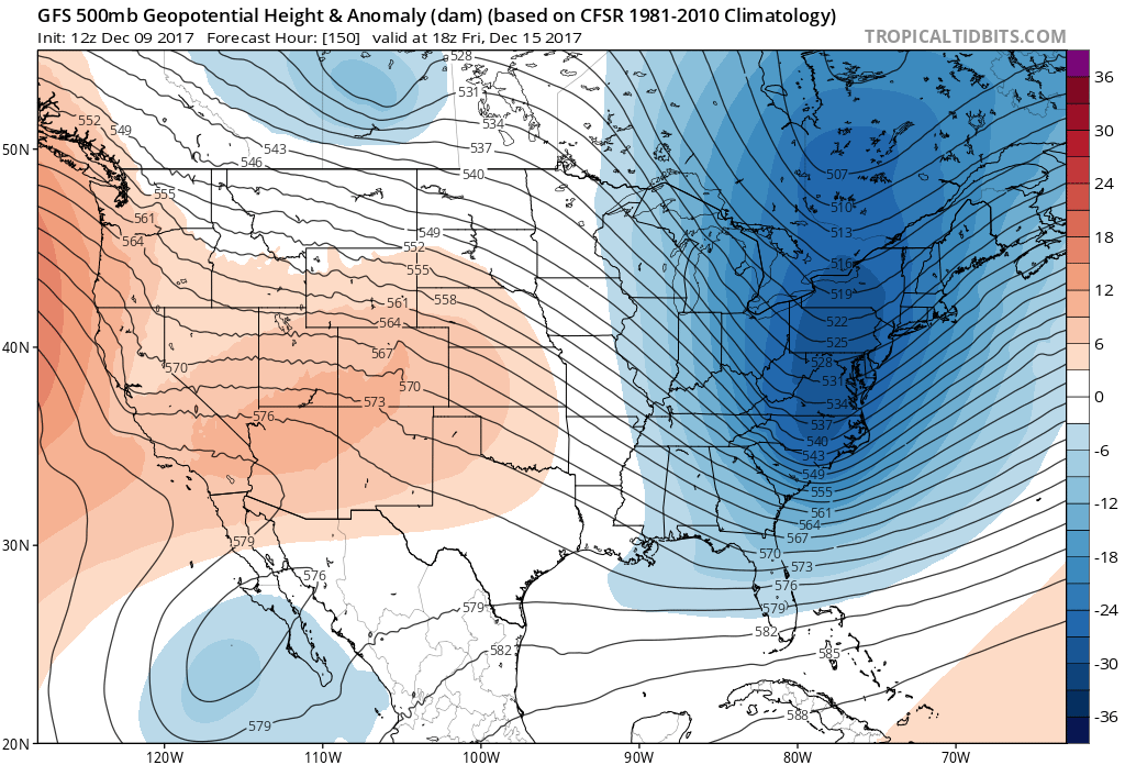
(click to enlarge)
Moving forward, some models have the pattern changing by week 2, by flipping the the PNA index from positive to negative right after the 20th of December. The GFS has picked up on this, as you can see below:
This is 2 weeks out, on 12/22 – Cold/wet out west, High pressure ridge/warmer out east.:

(click to enlarge)
Due to the SST out in the Eastern Pacific, I am not totally confidence on this pattern change around this time period. Based on the SST in the Eastern Pacific and the emergence/persistence of the Warm Blob again in the eastern Pacific, I don’t see this pattern to change that quickly.
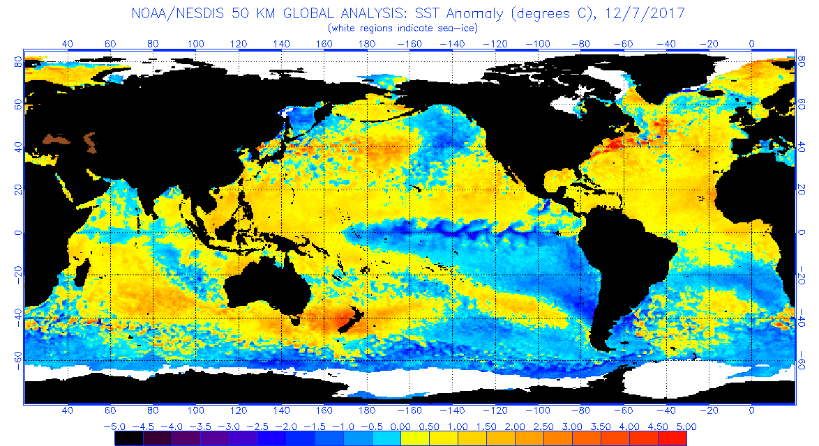
(Click to Enlarge)
As you can see above, as long as the Blob of warm water is by the Aleutian islands, and warm water is off the coast of California, it will be dry/drought like conditions along the West this winter, with more fires, below rain/snow and warm weather. The Midwest/Northeast on the flip side will again be effected by numerous PV’s, snow, blizzards, and just a brutal winter. I sound like a broken record!! LA Nina is very evident on this image in the Equator from South America, as cold water stretches from South America to the middle of the date line. This condition has helped suppress the southern jet stream, which will give the West Coast some cold weather from time to time this winter, but will keep CA dry! Stay Tuned!!!
Fire update:
Below are some websites of maps and information about the fires for those that are not in the area:
– http://www.ksbw.com/article/photos-southern-california-wildfires-seen-from-space/14376263
– http://www.latimes.com/hp-2/
– https://firemap.sdsc.edu/ This is the best fire map I have seen.
The Ventura Thomas Fire is still completely out of control. Based on information I have received from sources in agencies fighting the fires, they are trying to stop it from spreading towards Santa Barbara. This will be the story the upcoming week, as off shore flow, 90 degree weather, very windy and bone dry relative humidity will persist for the next 7 to 10 days! For those of you who have pictures of the fires, and stories, please email them to me at jason@realweatherforecast.com
May all of you be safe if you are in the line of the fires. Will update in the next day or so!!
–Dr. J
