Big Weather Pattern Changing to: +PNA…-AO…-NAO Across the Western Hemisphere…. Major Arctic air to filter down, which will bring Bitter Cold Outbreak for the East Coast Starting Next Week (PV), as a High Pressure sets in for all of California after this weekend, until Mid-December at the Earliest!!.
Synopsis:
A big change in the weather pattern will influence the climate teleconnection patterns, and revert to a : +PNA…-AO…-NAO across the Western Hemisphere/North American (See past discussions for an explanation of Teleconnection patterns or click this link: http://www.cpc.ncep.noaa.gov/products/precip/CWlink/daily_ao_index/teleconnections.shtml).
This will allow Arctic air with bitter cold temps filter down to the East Coast/Northeast, starting the middle of next week. As I have mentioned throughout this fall on previous discussions, California and the West Coast will be mild and dry this winter, and the midwest/northeast will be effected by numerous PV (Polar Vortex’s) throughout this winter, due to the warm SST in the eastern pacific and the reformation or the WARM BLOB! For the NYC/Tri-city areas, I am guessing there will be anywhere from 15″ to 45″ of snow through March, with 1 to 3 major blizzards. Folks, for those of you who live in the Northeast, this cycle will start for you by the middle to end of next week and should subside close or right before Xmas if the pattern flips. Usually strong high pressure ridges with a combination of a Hudson Bay low pressure and a +PNA pattern cycle, are usually roughly 21 days or so. If next week is the start of it, then around Christmas the bitter cold/snow should break and come back right after the New Year. The Midwest/Northeast will dominated by Arctic PV’s this winter, as a very strong high pressure ridge in Alaska will keep all of the West coast dry/mild for the foreseeable future and pound the Northeast/Midwest. See graphic below:
GFS American Forecast Model through December 10th – Notice the strong high pressure over Alaska and the West Coast, with the cold air over the Northeast. This pattern will be around more often than not this winter:
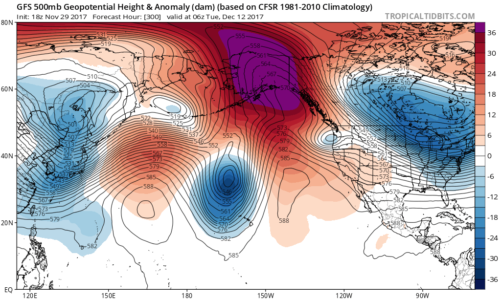
(Click to Enlarge)
Here is another graphic of a +PNA teleconnection pattern, so you can see how the pattern sets up:

(Click to enlarge)
Here is another graphic, which shows you how the Polar Vortex just circulates around the Hudson Bay in Canada, and the high pressure ridge along the West Coast. This was from 2013, however, this patten is very similiar to this winter upcoming. A -EPO is a Negative Eastern Pacific Oscillation. That combined with a +PNA will give North America the pattern we are about to have.
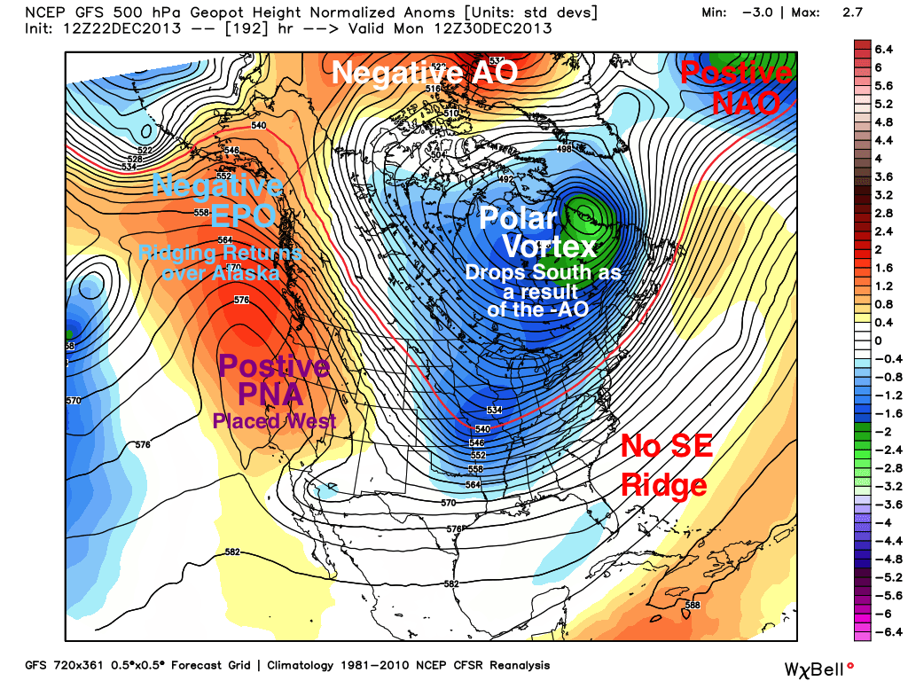
(Click to Enlarge)
I like the image above, as it really demonstrates how teleconnection patterns set up. Due to the warm SST temps and the blob in the eastern pacific, get use to this pattern this winter.
Moving on, for those of you who are in California, I am forecasting average to below average snow/rain north of Point Conception for this winter, with prolonged periods of dry/warm weather, due to the pattern I discussed above. For those of you who live south of Pt. conception, look for 7″ to 12″ of rain, depending on where you live. This will enhance the drought conditions we still have in Southern California, and perhaps might effect North California as well.
Snow wise, we are in trouble for California. As you have seen on TV and online, most resorts in the West are struggling to open, due to the lack of rain/snow, and very hot temps. The past week, most resorts have started making snow, as the nighttime temps just got cold enough. For the next 21 days or so, it will be a struggle to keep these resorts open, and if they are open, limited terrain will be the norm. I really wish I had better news if you like cold/wet weather in California and like to ski, but this will not be your winter to really enjoy it in the west. I hope I am wrong. I will have an updated discussion over the weekend as we head into December, and see when this pattern will shift to bring cold/wet weather to the West. In the meantime, enjoy the mild weather, as the folks in the Northeast are going to have to dig their heels in for the next 3 weeks to stay warm!
Dr. J
