Major Storm Cycle to hit CA Starting Today, Through beginning of Feb.
Weather Followers – I hope all of you and your loved ones are safe and healthy. It has been some time since I have written a blog on here, as most of my free time has been tweeting on Twitter about the weather. However, since most of my followers that subscribe to the blog requested for me to start to write again, I figured I would carve out time to do so as there is a very active pattern of weather starting today through Feb 1st, in California. Lets get into it.
La Nina – Most of you know we have a strong La Nina in the equatorial regions, which has suppressed the southern jet stream for the southern tiers states of the US. As you can see below in blue, it is still apparent along the pacific equator, but I have circled in red the area that is weakening. One of the reason for such dry/windy/warm weather this fall and winter has been La Nina. It has suppressed the southern jet stream, and created a high pressure dome in the eastern pacific. La Nina has created havoc with the tropical forcing of patterns, such as the MJO ( https://en.wikipedia.org/wiki/Madden%E2%80%93Julian_oscillation ). These patterns have allowed a blocking pattern to set up, which is why LA only has had 1.95″ of rain in downtown, prior to today, for the past 10 months. Look for the La Nina to continue to weaken as we progress thru winter and dislodge the persistence high pressure that has plagued most of California for the fall/winter. By the end of February, we will look at La Nina again and see what it looks like.

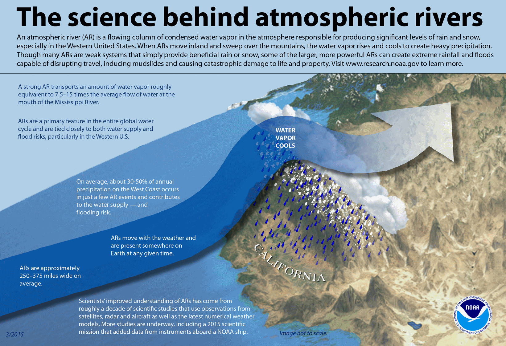
California’s Pattern – As I discussed above, the La Nina has created serious fire/drought/windy/warm temps from Fall through Winter. As I mentioned, La Nina is weakening, so changes in the atmosphere are upon us. Last week we had 90 degree temps all over CA, especially SoCal. Fast forward to today, and we are in a major winter pattern until around the 1st of Feb. High pressure is gone and is replaced with a long wave through, with an upper level low spinning around and bringing in storms. Now, by now, you have heard the media in their reports discussing an Atmospheric River is headed into California. Below is a diagram of what an ‘AR’ is:
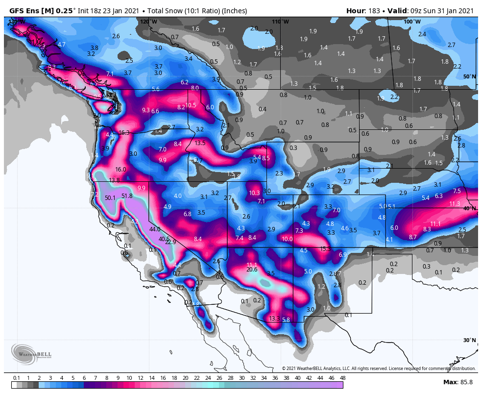
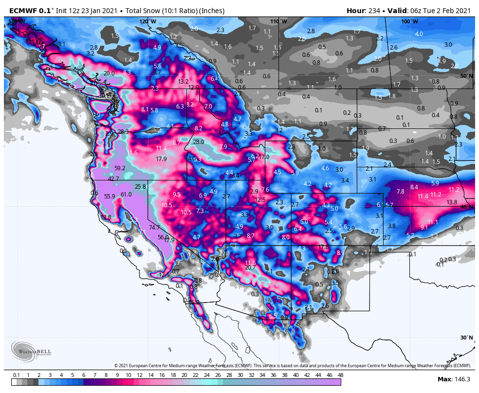
So, what does next week look like? Well, after a moderate storm tomorrow night into Monday, the AR will set up. Depending where you are in California, it could be potent, and it could be moderate. I am looking at a 48 hour window beginning Wednesday through Friday. Within this time frame, the AR, driven by a strong jet stream and upper level winds will steer the AR into California. Below are some models that show some differences for the State and SoCal:

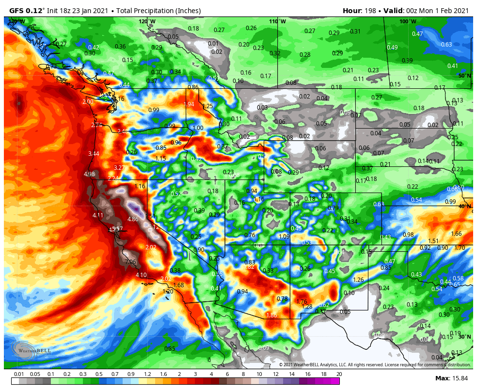
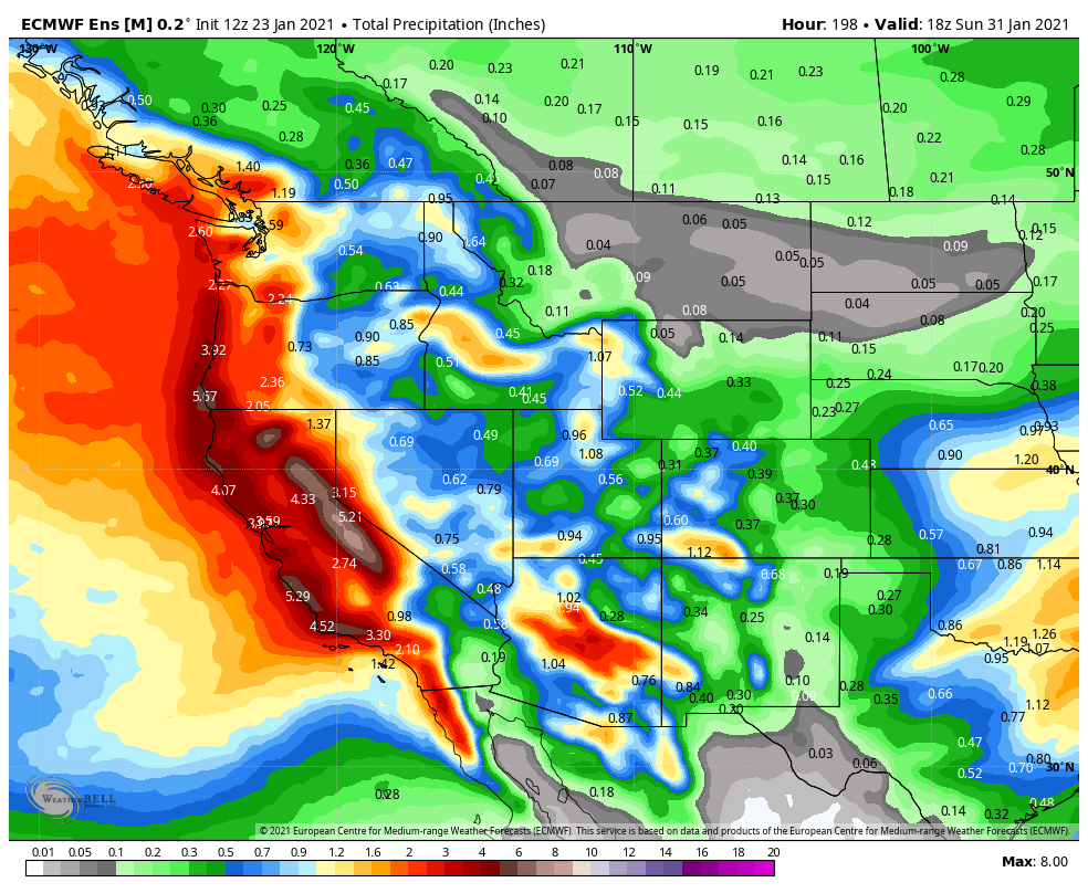
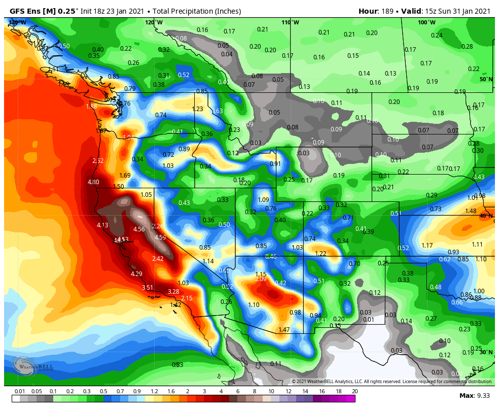
As you can see above, the AR is poised to strike above Pt. Conception north to the Central Coast next week. That is not to say that SoCal will not get any rain. In fact, LA, by Feb 1st, DTLA could receive anywhere from 2″ to 4″ inches of rain. Impressive. I am not holding my breath for the 5″ that was forecasted in LA yesterday by the models, but the burn scar areas should be prepared for major mud slides as orographic lifting will occur and lives could be lost if everyone is not prepared. This is a lot of rain forecasted for a 7 day period, so anyone that is in these areas, be prepared. If the AR shifts 100 miles north or south, that could be a major impact for debris flow and mudslides. In addition to the heavy rain next week, is the cold temps. Snow levels might be at 2K, with snow in the major mountain passes and maybe in the Antelope Valley. Stay tuned to your local media or the NWS at www.weather.gov to get your local forecast.
Snow – It has been a tough year snow wise in the Sierra and in the SoCal mountains. La Nina has created an erratic snow year, with some decent storms, but then a 3 week dry period. As you can see below from my friends at www.opensnow.com, BA puts this graphic out of the snow tally for the season in the Tahoe Basin, on their website. I believe they have a new forecaster for SoCal, so hopefully they can adopt this grid below, as it is helpful to determine where we are snow wise, and of course what the skiing looks like. As you can see, we are still way below average below, but we will make up ground this upcoming week.

Below are the snow forecasts for the upcoming week. This is exactly what we all need for a good base building snow pack in the Sierra’s and in SoCal.
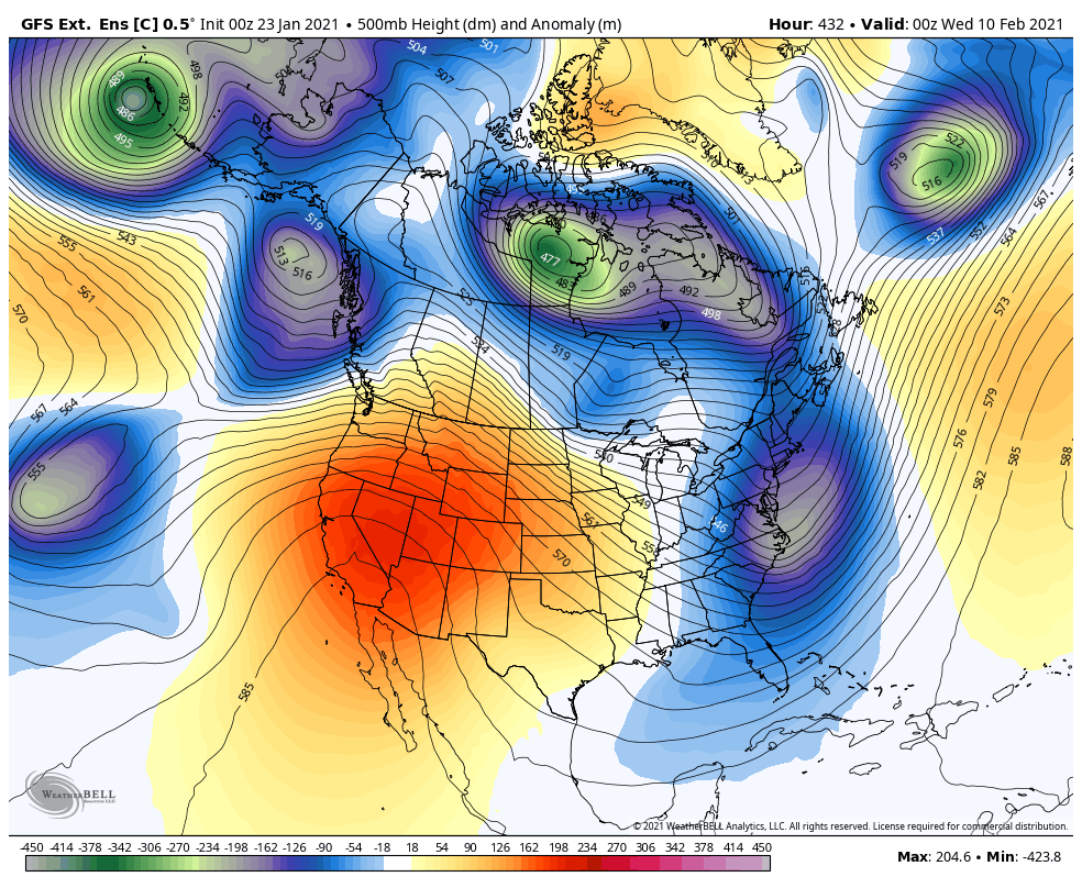
Long Range – Long range models show the long wave trough pushing east around the 3rd or 4th of Feb, in which case a high pressure ridge will takes its place and dry up CA. Time will tell how long the high pressure ridge sets up over the West Coast, but I will keep an eye on it and give an update later next week.
I will keep an eye on the AR and the setup for next week. For those of you near the burn areas, be prepared.
-JM
