Happy New Years from Real Weather Forecast!
Weather Followers,
Hope all of you had a safe and happy new year. 2020 marks the 3rd year that Real Weather Forecast has been in existence. I hope all of you enjoy the discussions, and my input/insight into the weather and how our climate is changing. I enjoy the feedback from all of you, either from this forum and on Twitter. Currently, below are some updates about some weather around the country and the world:
Australia:
– Australia is currently in a state of emergency, and bush fires have raged for weeks with no end insight. With 100+ degree temps, strong winds, and a severe drought, conditions are the worse they have been for some time. I have good friends that are in the city of Wollongong, as they had some of their cousins evacuate in some of the areas that are near the fires. They made it out ok, but without power/gas, and no cell service, things are not good down there. If you haven’t been following the fires, here are a few links if you are interested to follow the fires. and/or if you know of any loved ones:
Living in California, this really hits home. My thoughts and prayers go out to all of people down under that are effected by the bush fires.
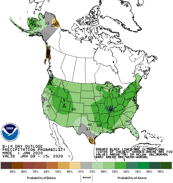
California Weather – Pretty benign weather for the next 10 days, as high a pressure ridge is building on the west coast with average to slightly below average temps and sunny weather. This is a welcome relief for the past few weeks, as major storms pounded SoCal and the southwest with feet of snow in the mountains. This pattern will be short lived, as I am forecasting a major pattern change to effect California and the west coast by the middle of the month. See the CPC 8 to 14 day forecast below showing this pattern change:
(Click to Enlarge)
(Click to Enlarge)
As you can see, the week of January 6th, things will start to change, as all the teleconnection patterns are going to be aligned together to hopefully allow some good storms to hit California the last 2 week of the month. In the interim, enjoy the nice weather!!
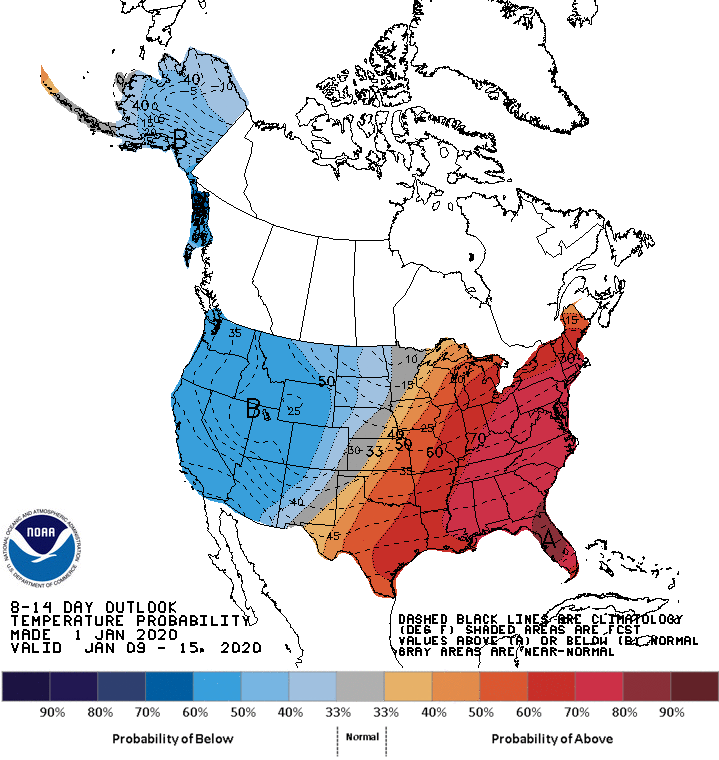
—Northeast: Rain, Rain and more rain. Temps are way above normal, as it was pretty warm for the Time Square Ball drop last night. More rain is foretasted this weekend, as no measureable snow is forecast for the foreseeable future for the coastal cities of the Northeast, like Boston/NYC/Phily. Snow might fall mountains ranges of upstate NY, Vermont, NH and Maine. The Polar Vortex (PV) has been hiding from the lower 48 all this fall/winter so far, as the Arctic Oscillation (AO) has been mostly positive this winter/fall. We need the (AO) to be negative, to dislodge the PV from the Arctic, and head down to the lower 48 to give most of those cities I mentioned some snow. Currently, it is very very positive. As you can see on the graphic above from the CPC, way above normal in temps through the week 2 period. This pattern looks to be locked in place through the middle to the end of January. Currently, I don’t see the PV coming down to the lower 48 and/or the Northeast anytime soon! I will keep you posted.
Next update this weekend!
-JM
