Volatile Weather to be the Norm this Spring/Summer, as a Possible Modoki El Nino Develops!!!
Hope all of my weather followers are doing well. Been awhile since I have posted on the blog, as most of my updates and discussions have been on twitter. For those of you who do not have twitter, and/or want to follow me, my handle is @realwxforecast. You can get updates a lot quicker, and will be able to see what is going on in the world of weather from all of my followers on there. Hope you join me! For those that like the blog, I will try to post a discussion one or twice a month during the summer, to give you updates on my thoughts, as well as the upcoming winter. Currently, the weather around the world is completely volatile. From the tornado activities in Wyoming yesterday, to the historic flooding in Maryland last month, to the Volcanos on the Big Island and Guatemala……mother nature is not happy! I can only image what is going to happen next, as the weather is becoming more unstable by the day. That being said, most of you want to know what the summer will bring and what a glimpse of fall/winter in 2018-2019 will look like. Here is goes…..
Summer Outlook:
Most of you who have followed me and know me personally, I always go back to my roots on the classes I took in Oceanography and Climatology. Therefore, I have posted the current SST (Sea Surface Temps) globally for me to discuss with you. See below:
(Click to Enlarge)
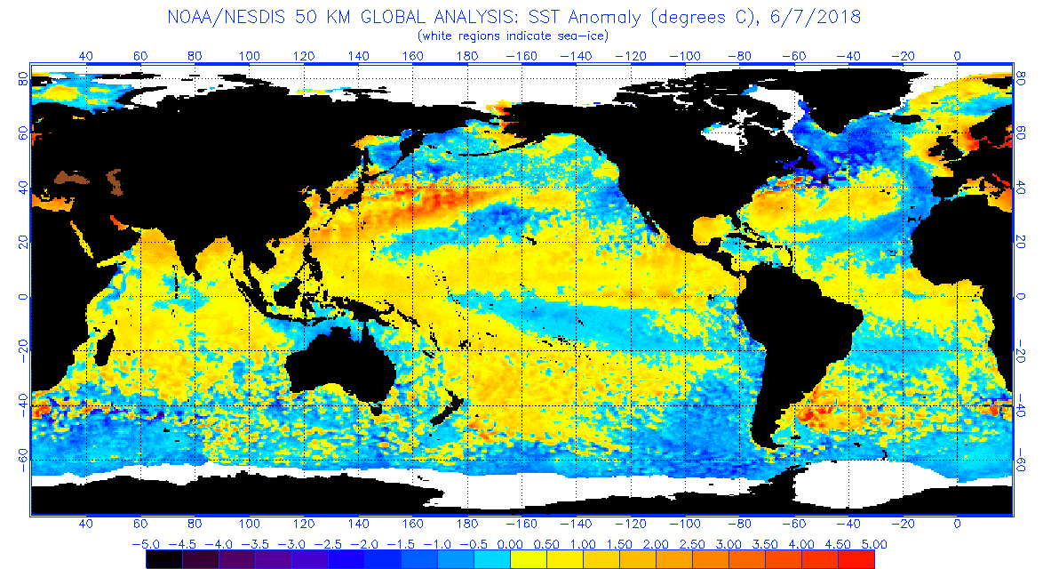
Couple of notes on the where the world is:
– The moderate La Nina (Cold water on the equator) is all but gone that dominated the past winter weather pattern. As you can see above, the cold water is almost gone…..replaced rapidly with warm SST. Models are showing a moderate to strong El Nino, with warm water replacing cold water at the equator through the fall. However, what does this mean? Is it going to be a typical heavy rain El Nino that is traditional to the West Coast of the US, especially SoCal? The answer is most likely no. Some blogs I have read and forecast models are showing a possible Modoki El Nino, which is not especially good news for the West Coast drought situation. Right now the models are showing the possibility of a moderate El Nino, with a Modoki position possibly. The latest JAMSTEC model shows a look similar to the Winter of 2014-15, which was bone dry on the West, and Blizzard/Cold on the Midwest/Northeast. Below is the infographic on the different El Ninos:

(Click to Enlarge)
I have some links before for those that want to dive a bit deeper into the ocean change and what this means. You can also track the El Nino this summer, on the JAMSTEC link below. We will have to keep an eye on this, as if it goes into the Modoki region, the West Coast is in trouble!!
Links:
http://www.jamstec.go.jp/frcgc/research/d1/iod/e/seasonal/outlook.html
https://earthscience.stackexchange.com/questions/2822/what-is-el-ni%C3%B1o-modoki
https://en.wikipedia.org/wiki/El_Ni%C3%B1o%E2%80%93Southern_Oscillation#ENSO_diversity
Moving on, the West Coast of the US has below SST’s for the last couple of months, hence the cool May/June they have had from the Marine layer. Inland is a different story, as the monsoon/continental high pressure over the divide has some serious heat inland, as the monsoonal season might start in the next few week. The coast of CA might be in the 60’s and inland might be 105+. Something to watch!!!!
The East Coast is another animal, as warm SST temps off of the coast has generated very extreme weather. May was down right miserable in the Northeast, with cold/wet weather one day, to hot, muggy, humid the following day. Look for that extreme temps to continue to take place, until the Bermuda High kicks in by the early part of July. For now, seasonal temps will continue until the end of the month
CFSv.2 temps for next 14-21
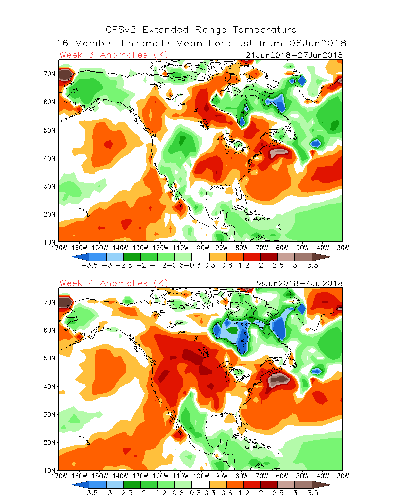
As you can see, the heat is on out west and the Northeast as we transition to July. I would have to say, if you want cooler weather, hang out at the coast, especially coastal communities out west. That is where the marine layer will have the most impact. For those of you who are in the midwest/Northeast/or plains states, it is going to be a very volatile summer for those areas. Between the cold air aloft, and the tropical flow from the Gulf of Mexico, this abnormal weather will continue!!! Be Careful!
Hurricane Season – This will be a very active summer. With Alberto hitting the southeast over Memorial day weekend as a Tropical Storm and Hurricane Aletta off the coast of Mexico in the Pacific…..we are getting an early jump on the season!!! Stay Tuned!!
In closing, some of you have asked for links to the Hawaii Volcano. Here is the USGS’s site on Kilauea: https://www.usgs.gov/news/k-lauea-volcano-erupts
Having visited this part of Hawaii recently, I never thought I see it in my lifetime of an eruption of this magnitude. My hearts go out to the people that have lost their property. There truly seems to be no end to the lava flow!!! Mother nature is angry everywhere.
Stay Tuned!!!!
JM
