
A Historic Winter begs the questions……….When will the Rain/Snow Stop in California??????

The winter of 2016-2017 will be going down in the record books, as California has received historic rain/snow, with no end in sight. For those of you who are in Southern California, the storm from this past Friday was one of the strongest storms to slam into So Cal in the last 20 years. From huge sink holes, major mud slides, trees toppled over, to flooding on major freeways…it had everything. The barometric pressure registered at was LAX during the peak of the storm was at 29.01”, which is comparable to a Category 1 Hurricane. Depending on where you lived, the rain gauges registered 2” to 6” of rain. The Bulls-eye was from western LA County to Santa Barbara county, which produced every type of weather possible. Once the storm went through LA County, the stormed continued it destruction, and created havoc on Southern California. Folks, this is just perfect example of what Central/Northern California has experienced this winter, and is currently experiencing this week. This is due to an abnormal number of atmospheric rivers (AR), which mainly have been aimed at central/northern California, but sometimes it slips down to So Cal, like last Friday.
The number #1 question I get asked is, “what is next?” Currently, northern California is getting slammed again with copious amount rain/snow……as they are close to the brink of having too much water. So Cal is getting the tail end of all these storms, with light mist/rain, and scattered showers, with cool dam weather. This will continue throughout the week. Up in Nor Cal, with Lake Shasta and Oroville dams at their maximum levels, among other rivers at their breaking points……..flooding is inevitable. Yes folks, there is such a thing as to much water. What Nor Cal needs is a break in the storms. Will we get it??? The short answer is no….the long answer is maybe. NOAA put out their 8 to 14 day forecast today, and it is interesting:
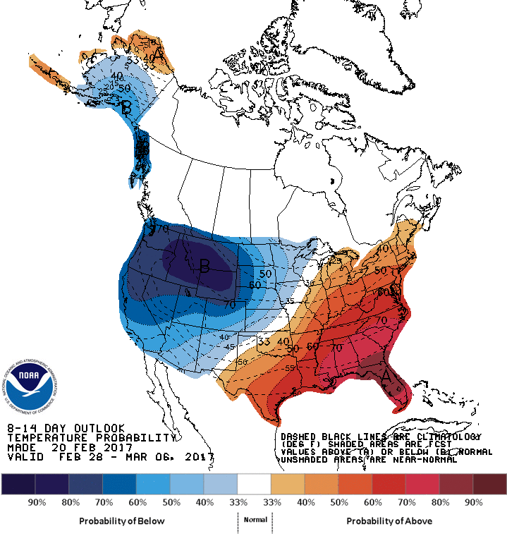
(click to enlarge)
As you can see, very cold artic air is doing to effect the West part of the US, while very warm weather will effect the Midwest to the East Coast. Folks in those areas, will experience 60’s and 70’s for high temps, 15 to 20 degrees above normal. On the West Coast, the opposite will happen…….very cold temps in the 50’s for highs in the LA area, to nighttime lows in the 30’s…….amazing. Here is the precipitation forecast:
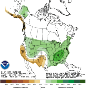
(Click to Enlarge)
As you can see, the 8-14 day forecast is dry. This is due to a huge high pressure system in Alaska, that will be responsible for dry weather on the West Coast, but cold weather, as the jet stream goes up and around the high pressure down the West Coast with cold temps. This is depicted below:
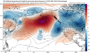
(click to enlarge)
As you can see, high pressure is in the red/orange and the cold temps on in blue. This is the GFS forecast model for Sunday, which if it verifies, will be sending down a cold storm to California for this weekend. Since it is 5+ days out, it is to far out to determine how much rain/snow we will get, but I am watching it. I am sure the TV readers are already talking about it for the weekend….stay tuned!!!
After the storm exits, you can see the pattern change, as much needed warm/high pressure is forecasted to return after next weekend:
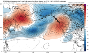
(click to enlarge)
As you can see, warm/dry weather is forecasted to return the first full week of March. Since this is 14 days out, I am not putting much stock into it, but for the time being the pattern will be changing to a warm/dry California starting sometime next week if the GFS verifies. Maybe the Midwest/northeast will get their last shot of winter when the flip of the pattern happens…..only time will tell and of course…subject to change.
More updates tomorrow, along with a snow report from my friends at Opensnow.com, and how much rain LA has gotten season to date, and if they will get to my 30″ mark, I forecasted last month.
Be Safe!!!
JM
