
Get your Seat Belts On, Winter is in Full Force this Week on Both Coasts!!!!

Thank you for all of you well wishes via email and through the comments section. I am trying to get an RSS feed up so everyone that subscribes to RSS, will get notified when I post a new discussion. In the meantime, check back periodically while my website designed Mara gets it going. Please give me any type of feeback, as Mara and I are making changes daily. Thanks!!
Quick Update Highlights –
- NYC will be close to a record High Temperature tomorrow, as it will be close to 60 degrees in the city. As it gets close to a record high, the temps will plummet down 35 degrees, and a storm front will hit the TRI-STATE area, with 6” to 12” of SNOW!! Yes, that is correct. WINTER STORM WARNINGS have been posted from Wednesday night into Thursday night. Again, this is all due to the AO/PV dropping from positive to negative. Once the storm moves through, this weekend should rise back into the 50’s…..insane weather. For those of you who live on Long Island and just bought snow blowers for this winter (YOU KNOW WHO YOU ARE!!), use them this weekend, as after this weekend, I don’t really see any cold/snowy weather through the end of the month, except one minor disturbance maybe next week that may warrent the blowers to come out.
- California – The Record winter of 2016-2017 continues!!!!!!! Very active weather this week, then about a week of quiet weather, then the onslaught of more rain/high elevation snow will hit CA starting around presidents weekend. Currently, another AR/Pinneapple express is hitting central and northern California. The good news with this, it is brining more rain. Bad news is, the snow levels are above 9000 feet, so it is melting any snow below that level in the mountains, hence flooding is occurring. Towns like Mammoth, Truckee….are under a Flood Warning from the NWS. Be prepared!!!! At the end of the week, another storm comes in, with colder temps and more rain. After that storm, there is about a 1 week period that all of California drys out before the next round of heavy rain/snow take hold! That is the time to repair any water damage property!!!!
- For So Cal, another good soaking yesterday into this morning. LA is over the annual rain fall amounts. I will post what they are by tomorrow, but we should be over 16” for the season. Average in DTLA is 14.93”. If what I am reading and seeing for the future on all of the climate/foreast models, I project DTLA will get over 30” of rain this season. Yes, I am going out on a limb and projecting that!! Starting next week, if the models are correct, Southern California should get copious amounts of rain starting next week, as the Asian Jet aims right at central and so cal. More later on that……..
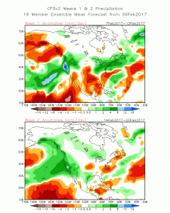
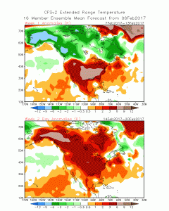
Climate Outlooks for the next few weeks from the CFSv2 from NOAA. The pattern change is obvious………..
Next 2 week Precipitation Outlook for the US
Temperature Outlook for the next 2 weeks: Pretty warm for the Midwest & East Coast. AO/PV is going positive!!
Next update later tomorrow……… Enjoy the warm weather and then snow for those in NY!!!
Recent Posts

Comments
Thanks for all of the wishes. We are continuing on making changes and adding content. We will also add a Marine section for Chopper Tom’s surf reports, for those surfers out there! Keep checking back!!!!